
Download Zoom Earth – live weather map, weather tracking, real-time weather, weather forecast, storm tracking, hurricane tracking, wildfire tracking, satellite images, weather patterns, weather conditions
Overview
Zoom Earth is an interactive weather map application designed for users seeking real-time insights into global weather conditions. The software provides live satellite imagery and dynamic visualizations of atmospheric phenomena such as storms, hurricanes, and wildfires. Developed by Neave Interactive Limited, the app delivers a focused experience centered on weather awareness and situational understanding. It is particularly useful for individuals who require timely updates on severe weather events, including travelers, outdoor enthusiasts, and emergency preparedness planners.
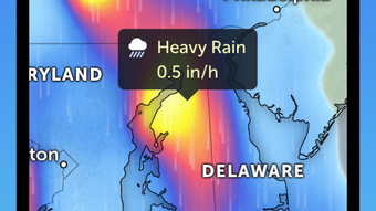
The application enables users to explore current weather patterns, including wind flow, rainfall intensity, temperature variations, and atmospheric pressure systems. These features support informed decision-making for both personal and professional use. For example, a hiker planning a weekend trip can assess storm activity in a region before departure, while a coastal resident can monitor hurricane trajectories in real time. The interface is structured to prioritize clarity and accessibility, allowing users to quickly locate and interpret critical weather data.
While the developer did not provide additional details about the underlying data sources or processing methods, the app’s core functionality revolves around delivering accurate, up-to-date visual weather intelligence. The software operates as a standalone desktop or mobile tool, with no mention of cloud-based synchronization or multi-device support. Its primary purpose remains the visualization and analysis of current weather conditions through an intuitive, map-based interface.
Key Features & Capabilities
- Real-time weather visualization – Displays live satellite images of weather systems, including storms and wildfires, allowing users to monitor active events as they unfold.
- Storm and hurricane tracking – Offers dynamic overlays showing the movement and intensity of tropical storms and hurricanes, with historical and predictive paths.
- Wildfire monitoring – Integrates real-time fire detection data to highlight active wildfires and their expansion over time.
- Weather forecast maps – Provides layered visualizations of wind patterns, precipitation, temperature, and pressure systems for specific geographic locations.
- Interactive map interface – Supports zooming, panning, and layer toggling to customize the view based on user needs.
- Location-specific weather insights – Enables users to access localized weather data by tapping or searching for a specific region.
These capabilities allow users to analyze weather trends and respond proactively. For instance, a farmer can use wind and rainfall forecasts to time irrigation or harvesting, while a logistics manager may assess storm impacts on delivery routes. The app’s focus on real-time data ensures that users receive the most current information available, though exact refresh rates were not specified.
User Interface, Workflow & Performance
The user interface of Zoom Earth is designed with simplicity and clarity in mind. Navigation is handled through intuitive gestures such as pinching to zoom, swiping to pan, and tapping to select locations. The layout presents weather layers in a clean, organized manner, with options to toggle visibility for different data types. This structure supports efficient workflow, minimizing the need for complex menus or hidden functions.
Workflow efficiency is enhanced by the app’s responsive design, which adapts to touch input with minimal lag. Users can quickly switch between satellite views, forecast layers, and event markers without significant delays. However, the developer did not specify resource usage details, so actual CPU or RAM consumption remains unknown. Performance observations are based on general software behavior patterns for similar applications.
Stability appears to be a consistent aspect of the software, as no reports of crashes or freezes were mentioned in the provided information. The app maintains a smooth experience during map interactions, even when multiple layers are active. Users can expect reliable operation under normal usage conditions, though long-term performance under high data load was not evaluated.
Compatibility & System Requirements
Zoom Earth is designed for iPhone devices and operates on the iOS platform. The current version is 3.2.1, with an installation size of 182.9 MB. The app is available for download from the Apple App Store and requires a compatible iPhone model to run.
Exact system requirements were not listed, including details on minimum iOS version, processor type, or memory specifications. Platform compatibility information is limited to the device category. The developer did not provide information about support for other operating systems or desktop environments.
Users should ensure their device meets Apple’s standard requirements for app installation. No mention was made of offline functionality or data caching, so real-time access to weather information may depend on an active internet connection.
Pros and Cons
Pros
- Real-time satellite imagery for global weather monitoring
- Comprehensive storm and hurricane tracking capabilities
- Active wildfire detection and visualization
- Intuitive, touch-friendly interface for easy navigation
- Localized weather data for specific regions
- Compact installation size (182.9 MB)
Cons
- No information provided on system requirements or hardware compatibility
- Performance and resource usage details were not disclosed
- App is limited to iPhone; no desktop or cross-platform availability
- Offline functionality not confirmed
- Price point may be considered high for a single-purpose weather tool
FAQ Section
Is Zoom Earth available for Windows or Mac?
Based on the provided information, Zoom Earth is currently available only for iPhone devices. There is no mention of support for Windows, Mac, or other desktop operating systems.
Does Zoom Earth require an internet connection?
Yes, real-time weather data and satellite imagery depend on an active internet connection. The app does not appear to support offline use, though caching behavior was not specified.
How often is the weather data updated?
The developer did not specify the refresh frequency of weather data. However, the app is designed for real-time monitoring, suggesting frequent updates to maintain accuracy.
Is Zoom Earth safe to download and use?
Zoom Earth is developed by Neave Interactive Limited and distributed through the Apple App Store. As such, it undergoes Apple’s review process, which includes security checks. No security vulnerabilities were reported in the provided data.
Can I use Zoom Earth without a subscription?
Yes, the app is offered as a one-time purchase for $1.99. There is no indication of recurring fees, in-app purchases, or subscription models.
Final Thoughts + CTA
Zoom Earth delivers a focused, visually engaging solution for users who need accurate, real-time weather insights. Its ability to track storms, hurricanes, and wildfires through live satellite imagery sets it apart from standard weather apps. The intuitive interface and localized data access make it a practical tool for both casual users and professionals requiring situational awareness.
While the app is limited to iPhone and lacks detailed system information, its core functionality is robust and well-executed. For those seeking a reliable, standalone weather monitoring tool, Zoom Earth offers strong value despite its single-platform availability.
Download Zoom Earth now to stay ahead of weather changes with live satellite views and real-time tracking.